Tornado Reports
Sort by Time Sort by Rating Sort by State Sort by County| Time | Rating | Radar | State | County | Location | Narrative |
|---|---|---|---|---|---|---|
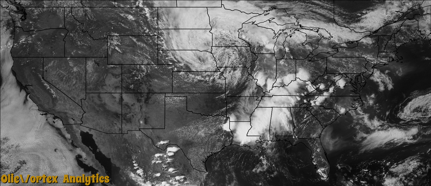
| 20:12Z | EF0 | KMPX | MN | Anoka | Lexington | An EF-0 tornado touched down near the intersection of Highway 10 and Central Avenue in Blaine, then traveled approximately 6.1 miles northwest to one half mile northwest of the intersection of County Highway 14, and Hanson Boulevard in Coon Rapids. It had maximum wind speeds of 70 to 80 mph. Most of the damage was associated with trees and power lines blown down along the path length. Some damage occurred when trees fell on homes. |
| 20:21Z | EF1 | KMKX | WI | Fond Du Lac | Alto | This EF1 tornado touched down about 4.4 miles west-southwest of the town of Alto in Fond Du Lac County, on Marshview Road, about one-third of a mile north of Lake Maria Road, and tracked about 2.6 miles to the north-northwest before crossing into Green Lake County, about 3.7 miles south-southwest of Fairwater, at County Road S approximately 1/4 mile east of Schure Road. This tornado exhibited three separate damage tracks within the path, suggesting three separate vortices formed and dissipated during the life span of the tornado. The average path width was 75 yards, with a maximum path width of 105 yards. The tornado blew over trees and flattened a pole shed. The EF1 rating was determined by using DI 21(MBS) DOD5 LB to EXP with estimated winds speeds of 105 mph. The exact starting point was 43.77112/-88.88480 and the exact ending point was 43.78370/-88.88558. |
| 20:31Z | EF1 | KMKX | WI | Green Lake | Markesan | This EF1 tornado crossed into Green Lake County from Fond Du Lac County, about 4.9 miles east-southeast of Markesan, at County Road S approximately 1/4 mile east of Schure Road, and traveled a little over 2 miles to the north-northwest before dissipating approximately 3.7 miles east of Markesan, about 1200 feet northwest of the intersection of Utley Road and County Trunk Highway Q. The average path width was 75 yards, with a maximum path width of 105 yards. The tornado blew over trees and blew a door and a side panel off a pole shed. Roof shingles were also blown off of several buildings, with one home having minor roof, gutter and awning damage. The EF1 rating was determined by using DI 27(TH) DOD4 LB toward EXP with estimated winds speeds of 100 mph. The exact starting point was 43.78370/-88.88558 and the exact ending point was 43.79798/-88.91194. |
| 20:36Z | EF1 | KMKX | WI | Fond Du Lac | Fairwater | This EF1 tornado touched down approximately 2.3 miles of northwest of Fairwater, about 200 feet southeast of the intersection of Watson Road and Searl Road/County Line Road, and traveled nearly parallel to County Line Road for almost a mile to the north-northwest before crossing County Line Road about 2000 feet north of Carter Road into Green Lake County. The average path width was 60 yards, with a maximum path width of 100 yards. The tornado uprooted trees and tore away a wall and part of the roof of a barn. The EF1 rating was determined by using DI 1(SBO) DOD4 EXP toward UB with estimated winds speeds of 95 mph. The exact starting point was 43.66761/-88.86583 and the exact ending point was 43.70275/-88.88517. |
| 20:38Z | EF1 | KMKX | WI | Green Lake | Green Lake | This EF1 tornado entered into Green Lake County from Fond Du Lac County at Searl Road/ County Line Road about 2000 feet north of Carter Road into Green Lake County. The average path width was 60 yards, with a maximum path width of 100 yards. The tornado uprooted trees and tore away metal panels off the roof of a pole shed. The EF1 rating was determined by using DI 21(MBS) DOD 3 EXP with estimated winds speeds of 95 mph. The exact starting point was 43.70275/-88.88517 and the exact ending point was 43.72962/-88.90737. |
| 20:55Z | EF0 | KSHV | TX | Shelby | Meldrum | The National Weather Service conducted a storm survey in Shelby County and concluded that damage was the result of an EF0 tornado. Numerous trees were uprooted and snapped off and small branches were found across the damage path. |The tornado touched down northeast of Timpson, Texas near FM 947. As the tornado traveled southwest, it snapped several trees and branches. It crossed Hwy. 59 just south of Timpson before lifting. |
| 22:00Z | EF0 | KSHV | TX | Shelby | Arcadia | The National Weather Service conducted a storm survey in Shelby County and concluded that damage was the result of an EF0 tornado. Numerous trees were uprooted and snapped off and small branches were found across the damage path which started along CR 4060. The tornado moved south-southwest crossing FM 138 knocking over trees before lifting. |
| 01:31Z | EF1 | KLOT | IL | Du Page | The Meadows | A National Weather Service storm survey confirmed an EF1 tornado touched down near Sunnydale Park and lifted near 55th and Main in Downers Grove. Most of the damage was to trees. Many mature hardwood trees had been snapped or knocked down. A fence was blown down at Downers Grove High School. An estimated 35 homes were damaged by falling trees. |
| 01:48Z | EF1 | KLOT | IL | Cook | Cumberland | A tornado touched down near the intersection of We Go Trail and Golf Road and moved north-northeast before lifting near the intersection of North Pine Street and Kensington Road. Most of the damage was fallen trees, a few of which fell onto houses causing structural damage. An estimated 2,000 trees were damaged in Mt. Prospect with 130 completely blown down or that needed to be removed. Most of the tree damage was in and near the path of the tornado. |
Storm reports are derived from "The Storm Events Database" (National Centers for Environmental Information) and/or "Past Storm Reports" (Storm Prediction Center).